The Goffstown Rail Trail, managed by the Goffstown Parks & Recreation Department and supported by the Friends of the Goffstown Rail Trail, is a scenic and popular path for walking, running, and biking. The trail begins at the west end in Goffstown Village center, travels through Grasmere and Pinardville, and continues directly into Manchester as the Piscataquog Trail with no clear signage marking the transition—look for the 0.0 mile marker near the city boundary to orient yourself.
Despite passing close to homes, businesses, and town facilities in some areas, much of the 5.56-mile route offers a peaceful, wooded experience with scenic views of Glen Lake and Namaske Lake. Trail users should be aware that six road crossings offer paved public parking, but additional informal parking areas exist along the trail and may not be shown on maps like Trail Finder.
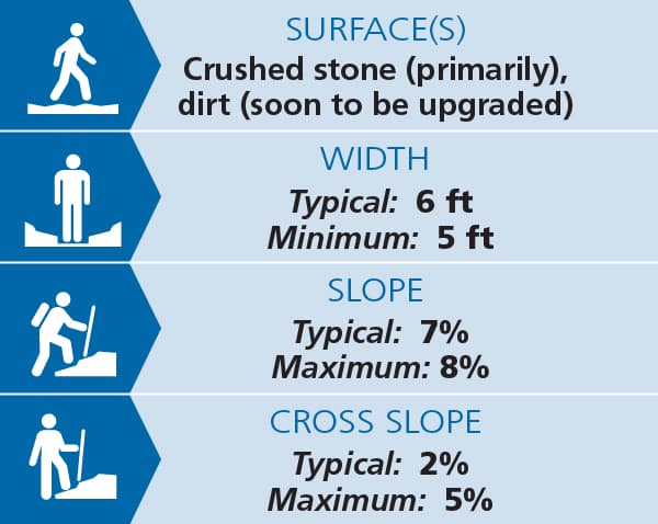
Trail surface upgrades have been a long-term community effort led by the Friends of the Goffstown Rail Trail. As of a 2025, 98.6% of the trail features a 5+ foot wide compacted nitpac (crushed stone) surface meeting town specifications. The only unimproved section—a 400-foot stretch near the Shell Station on Mast Road—is level and highly passable, and it is slated for improvement in 2026.
Two crossings of busy NH-114 (Mast Road) are protected by button-activated pedestrian hybrid beacons, which stop traffic with overhead lights (7 seconds of solid red followed by 15 seconds of flashing red, during which drivers may proceed if the lane is clear).
Mileage markers are posted every 0.5 miles, starting at 0.0 near the Manchester line and ending at 5.5 at the granite abutment over the Piscataquog River.


Trail conditions can change without warning. Trail last assessed: 7/01/2025
The rail trail is managed by the Goffstown Park and Recreation Department. The non-profit organization, Friends of the Goffstown Rail Trail provides the Park Department with volunteer services related to arranging the design, funding, construction, and maintenance of the trail. For more information, visit the trail manager websites or contact:
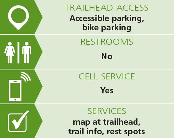
Goffstown Park & Recreation DepartmentFor access to the western end of the trail: Starting from the Goffstown Town Hall (16 Main St), travel west along NH-114 and 100 yards after crossing the bridge over Piscataquog River turn left onto Factory Street. Proceed just 100 yards to reach the trail crossing. Mileage marker 5.5 and western end of the trail is 100 yds to the left. The trail to the right (heading east) is towards Manchester. There is designated handicapped parking at this location, as well as at the four additional mid-trail parking areas designated on the map. Access from these parking areas to the trail is barrier free.
For access to the eastern end of the trail: Vehicle access to the eastern end of the trail is not possible; however, pedestrian/bicycle access is possible from the parking lot for Goffstown Sarette Park at 36 Laurier St, (Goffstown) Manchester. If proceeding west along NH-114A from Manchester, 0.2 miles after passing the Manchester/Goffstown boundary, bear right onto Laurier St. Proceed another 0.2 miles and turn right into the parking lot, keeping to the left. The bike/ped passageway through the fence is next to the locked vehicle gate. It is one-quarter mile along the park service road to reach the rail trail. On the trail, Goffstown village is 5.4 miles to the left (heading west) and the Manchester Fisher Cats Northeast Delta Dental Stadium is 2.2 miles to the right (heading east). There is no accessible parking at this location.
Success! A new password has been emailed to you.